This article was co-authored by wikiHow staff writer, Jennifer Mueller, JD. Jennifer Mueller is a wikiHow Content Creator. She specializes in reviewing, fact-checking, and evaluating wikiHow's content to ensure thoroughness and accuracy. Jennifer holds a JD from Indiana University Maurer School of Law in 2006.
There are 12 references cited in this article, which can be found at the bottom of the page.
This article has been viewed 22,320 times.
Learn more...
Latitude and longitude coordinates give you the exact location of anything in the world, making it easy for you to tell others where you are. The easiest way to find these coordinates is to use a GPS (Global Positioning System) receiver. However, even if you happen to be without a working GPS receiver, there are still ways for you to estimate your longitude.
Steps
Estimating Longitude Using the Sun
-
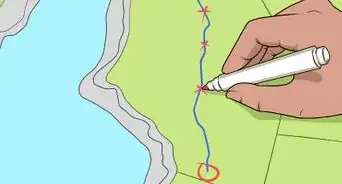
1Record the top point of an object's shadow over the course of an hour. Starting at around 11:30 a.m. local time, position a stick or pencil so that it is standing straight up and casting a shadow. Mark the spot where the stick is standing and the point at the end of the shadow. Continue marking the shadow every 5 minutes over the course of the next hour, taking note of the time when you made the point.[1]
- If you have a piece of paper and a pencil handy, that's the easiest way to record your shadow observations.
-
2Find the shortest shadow to determine local noon. Measure from the dot where the object stood to the dot you used to mark the tip of the shadow. Most of these lines will be diagonal, so a ruler is more precise than simply eyeballing it. The shortest distance is the time when the sun was highest in the sky, known as local noon. Refer back to the time you recorded that spot and you have the time.[2]
- The time when the sun is highest in the sky is referred to as "local noon." It might not necessarily be 12 noon — it could be any time between 11:30 a.m. and 12:30 p.m.[3]
- If you know the time of sunrise and sunset, you can also calculate local noon that way. Add the times of sunrise and sunset, using 24-hour time, then divide by 2. The result will be local noon. For example, suppose the sun rises at 6:30 a.m. and sets at 7:30 p.m. (19:30). Add the two half-hours first to get one hour, then add the hours together to get 26 (19 + 6 + 1). Divide by 2 and you get 13 hours, or 13:00, which would be 1:00 p.m.[4]
Advertisement -
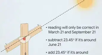
3Check the UTC time when it was local noon. Coordinated Universal Time (UTC) is the time at the Prime Meridian, which has a longitude of 0º. Look up UTC time online to determine the UTC time when it was local noon.[5]
- The easiest way to do this is to use an online time zone converter, such as the one at https://www.thetimezoneconverter.com/. Some of these time converters automatically account for whether the area observes daylight savings time, so take that into consideration when entering the time of your local noon.
-
4Calculate the difference between local noon and UTC noon. Subtract your local time from UTC time to find the difference. If your local time is earlier than UTC time, you are west of the Prime Meridian. If your local time is later than UTC time, you're east of the Prime Meridian.[6]
- For example, suppose you've determined that local noon at your location is 12:42 p.m. Since your location observes daylight savings time, you would subtract an hour to bring the time to standard time, so your local noon is actually 11:42 a.m. If you use a time converter, you'll find that when it is 11:42 a.m. in your location, it is 16:42 UTC. You are west of the Prime Meridian and there is a 5-hour difference (300 minutes).
-
5Add 1º longitude for every 4 minutes' difference between UTC time and local time. Take the number of minutes difference between your local noon and UTC noon and divide it by 4. That'll tell you roughly the longitude of your location.[7]
- To continue the previous example, you have a 300 minutes' difference between local time and UTC time. Since 300 divided by 4 is 75, your longitude is 75º west.


Finding Longitude on a Map
-
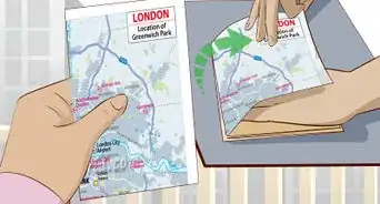
1Choose a regional map from a reliable source. Regional maps typically have enough local detail that you'll be able to figure out your location based on roads, rivers, or other landmarks in the area. Military and government-issued maps are typically the most reliable, but a commercial map can also be helpful, especially for a smaller localized area.[8]
- If you choose a map that covers too broad of an area, there might not be enough detail for you to figure out where you are.
- Because of the projection required to render a flat map of the Earth's surface, large-scale maps, such as atlases, are only accurate to a certain degree. However, they can still be helpful in a pinch.
-
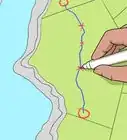
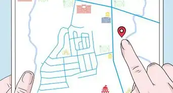
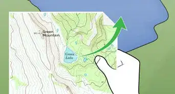
2Pinpoint your location on the map using landmarks. Maps typically identify major natural and manmade landmarks, such as rivers and roads. Look around you and compare the area where you are to the map. You might have to walk around a bit to get your bearings and find the right spot on the map.[9]
- If you're not sure of the location you've chosen, use the map as a guide. For example, suppose you find a spot that you think is your location. According to the map, if you're correct, there is a lake approximately 500 feet (150 m) north of you. Travel north until you see the lake.
-
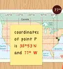
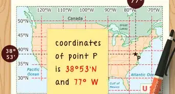
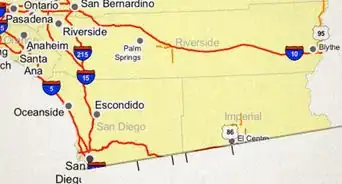
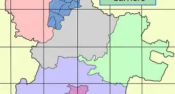
3Identify the nearest longitude line to your point that's closest to the Prime Meridian. Each longitude line on a map is labeled with a numerical value. The Prime Meridian is at 0º, then the numbers increase to the east and to the west, ending at 180º on the opposite side of the globe from the Prime Meridian. Different maps use different scales, so you might have one longitude line for every degree or you might only have one for every 10 degrees.[10]
- For example, suppose your location is about halfway between the line for 70º and the line for 80º. You would look at the line for 70º initially as your longitude value. However, since your location is actually past that line, you need to go one step further to get the actual longitude.
-
4Estimate the distance between your location and the longitude line. Unless your location happens to be exactly on a longitude line, you're not going to find an exact longitude value on a map. To make a good estimate, add the fractional distance from your location to the nearest longitude line that's closest to the Prime Meridian.[11]
- To return to the previous example, if your location is about halfway between the line for 70º longitude and the line for 80º longitude, your longitude would be 75º. There are 10 degrees of longitude between the 2 lines on your map, and half of 10 is 5. You would add 5 to the value for the longitude line nearest the Prime Meridian, 70º, to get 75º.
- Note that you could also get the same answer if you used the further line and subtracted your fractional distance. Just keep in mind the direction the values are increasing.
- If you have a ruler handy, it can help you make a more precise estimate, especially if it's difficult to eyeball.
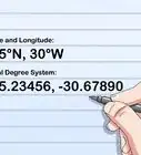
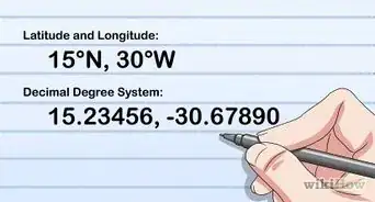
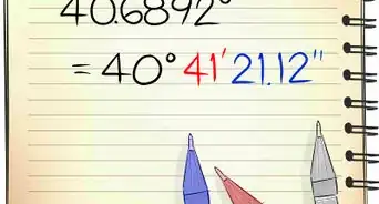
- Longitude is more precisely measured in minutes and seconds (with 60 seconds in a minute, just like time), or in decimal degrees. Decimal degrees are easier to use with a paper map if you need to get that precise.
-
5Label your longitude east or west. Longitude values are expressed as east or west depending on their direction from the Prime Meridian. Think of the Prime Meridian as the center. If the values of the longitude lines increase as you move from left to right, you're east of the Prime Meridian. If they're increasing from right to left, you're west of the Prime Meridian.[12]
- Most maps will also indicate whether the longitude is east or west, but it's good practice to know how to figure this out for yourself.
- If you're expressing longitude in decimal degrees, longitude values west of the Prime Meridian are expressed as negative numbers. To return to the previous example, if your location is 75.5º west of the Prime Meridian, your longitude would be -75.5º.
-
6Identify the map's projection and datum if you need to share your coordinates. Cartographers use a projection to create an accurate flat map of the round Earth. Likewise, the datum is a model of Earth used to plot latitude and longitude lines on the map. A good map will tell you which projection of the Earth was used to create the map, as well as the vertical and horizontal datum. Since you're looking for your longitude, pay particular attention to the vertical datum. This information will typically be listed in a key somewhere at the top or bottom of the map.[13]
- For projections, you'll typically see the name of the person who developed it, the aspects of the projection, or a combination of the two. The Mercator projection is perhaps the most well-known projection, and the most commonly used.
- The datum is typically 3 capital letters followed by 2 numbers that indicate the year the datum was last updated. For example, the datum used by GPS systems is WGS84, the "World Geodetic System" that was created in 1984.[14]
- If you needed to tell anyone your location, you would also need to tell them the datum used so they could use the same datum to enter your coordinates. Otherwise, they could be several hundred miles or kilometers off from your actual location.


Using GPS
-
1Turn on your GPS receiver. When you power on your GPS receiver, it will immediately start searching for satellite signals to coordinate so it can tell you where you're located. You might have to enter a general geographic region, such as the name of the country, to set it up properly.
- While most smartphones are equipped with GPS capability, they might not be as precise as dedicated GPS receivers. They also might not give you the longitude and latitude coordinates for your location.
-
2Set your GPS receiver to the correct coordinate system. GPS receivers use different coordinate systems, called datums. Depending on the system used, one location could have different coordinates. Check the settings of your receiver and make sure both systems listed are the same. If not, change the system you get coordinates in to match the system the coordinates are derived in.[15]
- Most GPS receivers derive coordinates using the WGS84 datum. However, your receiver might be displaying coordinates using a different datum. This can result in "datum shift," which causes your coordinates to be off. The difference on the ground can translate to several hundred feet or meters off.
- Usually, it doesn't matter exactly which datum you're using. Just make sure the 2 listed are the same.
-
3Read the coordinates for your location. Your receiver's display will show the latitude and longitude coordinates for your location. Latitude is listed first in degrees north or south. Longitude is the second value, with degrees east or west.[16]
- Longitude might be further specified using minutes and seconds (with 60 seconds in a minute, just as with time measurement) or as a decimal. For example, the longitude of Paris, France is 2º 29' E, which you would read as "2 degrees, 29 minutes east."[17]


Warnings
- If you're transmitting your location coordinates to someone else, always tell them which coordinate system you're using. They might not be able to find the right location if they're using a different system.[18]⧼thumbs_response⧽


-Step-14.webp)

References
- ↑ https://youtu.be/hL9AoZCxzMQ?t=32
- ↑ https://youtu.be/hL9AoZCxzMQ?t=147
- ↑ https://astro.unl.edu/naap/motion1/tc_finding.html
- ↑ https://www.globe.gov/support/faqs/data-entry/measurement-times
- ↑ https://www.rmg.co.uk/sites/default/files/GCSE%20Astronomy%20Coursework%20-%20Shadow%20Stick%20or%20Sundial.pdf
- ↑ https://www.rmg.co.uk/sites/default/files/GCSE%20Astronomy%20Coursework%20-%20Shadow%20Stick%20or%20Sundial.pdf
- ↑ https://www.rmg.co.uk/sites/default/files/GCSE%20Astronomy%20Coursework%20-%20Shadow%20Stick%20or%20Sundial.pdf
- ↑ https://www.presby.edu/doc/military/FM3-25-26.pdf
- ↑ https://flexbooks.ck12.org/cbook/ck-12-interactive-middle-school-math-6-for-ccss/section/5.9/related/lesson/coordinate-locations-on-a-map-msm6/
- ↑ https://gisgeography.com/latitude-longitude-coordinates/
- ↑ https://gisgeography.com/latitude-longitude-coordinates/
- ↑ https://gisgeography.com/latitude-longitude-coordinates/
- ↑ https://www.presby.edu/doc/military/FM3-25-26.pdf
- ↑ https://www.icsm.gov.au/education/fundamentals-mapping/datums
- ↑ https://www.nps.gov/gis/gps/gps4gis/how2s_byCatagories/others/2004forFireMgmt/2_Slides_Using_Maps_with_GPS.pdf
- ↑ https://journeynorth.org/tm/LongitudeIntro.html
- ↑ https://www.nationalgeographic.org/encyclopedia/longitude/
- ↑ https://www.nps.gov/gis/gps/gps4gis/how2s_byCatagories/others/2004forFireMgmt/2_Slides_Using_Maps_with_GPS.pdf
About This Article